|
Watson Technical Consulting
110 Deerwood Court, Rincon, GA USA 31326
Watson Technical Consulting (WTC) specializes in meteorological hazard assessments and
remote sensing applications to environmental monitoring and modeling. WCT has modeled the
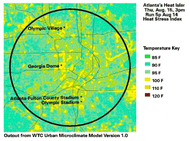
Atlanta metroplex, showing regional variation in temperature and heat index. This map
shows 15°F differences in heat index in areas separated by as little as a few hundred
yards.
Urban Ecosystems and Heat Islands
WTC has developed a methodology for Urban Planners to assess the impact of development
on the environment, and develop cost effective mitigation measures.
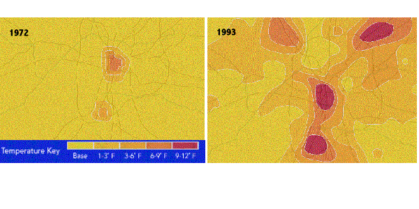
One study of particular regional interest is an analysis of the Urban Heat Island of
the city of Atlanta, Georgia. This study was conducted for the US Environmental Protection
Agency, the Atlanta Regional Commission, and American Forests. Over the last two decades,
the city of Atlanta has seen tremendous growth. This growth has resulted in many areas
which were heavily vegetated to become covered in concrete. This causes many changes in
the local weather, or microclimate. One of the most obvious is that temperatures in dense
urban areas are higher than the neighboring countryside. The two maps below show average
temperatures increases, as calculated by WTC's microclimate models and verified by
satellite data, for two of the four target years: 1972, 1978, 1986, and 1993.
 Why do heat islands
matter? First, heat islands cost money, especially in the southern US. In a study WTC
conducted for the US Army, the Savannah Georgia heat island costs a typical residence over
$25 per year. That doesn't sound like much, but when multiplied by the number of homes in
the city it starts to add up. In addition, the $25/year number is only the average direct
cost. We have to pay for the extra generating capacity the power company must maintain,
but only use a few days a year. Secondly, heat islands generally indicate a lack of
vegetation. A lack of vegetation usually means that other problems are present, among them
increased levels of pollution, intense stormwater runoff problems, etc. WTC is working
with non-profits, local governments, and the business community to address these problems
on a local level, through low cost, non-regulatory means. Why do heat islands
matter? First, heat islands cost money, especially in the southern US. In a study WTC
conducted for the US Army, the Savannah Georgia heat island costs a typical residence over
$25 per year. That doesn't sound like much, but when multiplied by the number of homes in
the city it starts to add up. In addition, the $25/year number is only the average direct
cost. We have to pay for the extra generating capacity the power company must maintain,
but only use a few days a year. Secondly, heat islands generally indicate a lack of
vegetation. A lack of vegetation usually means that other problems are present, among them
increased levels of pollution, intense stormwater runoff problems, etc. WTC is working
with non-profits, local governments, and the business community to address these problems
on a local level, through low cost, non-regulatory means.
For more information contact:
Chuck Watson, (912) 826-4462,
Next Page.
|